
Post Summary – Alum Cave Trailhead Smoky Mountains
There’s just something about the Smokies that makes me smile and feel at ease every single time I’m there. The layers of ridges, that misty mountain air, and trails that really make you slow down and take it all in. If you’re looking for a hike that gives you incredible views and a good hiking challenge, Alum Cave Trailhead is one to put on your list.
The Alum Cave Trailhead starts right off Newfound Gap Road and takes you through some of the most beautiful sections of Great Smoky Mountains National Park. You can do a shorter out-and-back to Alum Cave Bluffs, or keep climbing all the way to Mount Le Conte, which is one of the tallest peaks in the park.
Whichever route you take, you’re getting cool air, mountain views, and a trail that keeps things interesting the whole way up. Just make sure to arrive early, the Alum Cave Trailhead parking area fills up fast, especially during fall and weekends. Here’s everything you need to know before you go!
SEE ALSO: What to Pack When Hiking
Trail Name:
Alum Cave Trail
It’s called Alum Cave Trailhead, but don’t expect a deep cavern. This spot is actually a huge bluff that feels more like a natural amphitheater than a cave. Getting there is half the fun though. Along the way, you’ll cross a few creeks, climb up stone stairs, walk through a narrow rock tunnel, and stop at plenty of viewpoints that’ll have you pulling your phone out every few minutes.
Location:
The Alum Cave Trailhead is right off Newfound Gap Road (U.S. 441), which is one of the most scenic drives in the Smokies. I highly recommend setting aside some time to just drive this road and stop at a few of the overlooks if you have time! If you’re coming from Gatlinburg, it’s about 10.5 miles south of the Sugarlands Visitor Center.
To find it, you can just plug “Alum Cave Trailhead” into Google Maps, and it’ll take you right there. If you prefer exact coordinates for hiking apps or something, use 35.6290° N, 83.4462° W.
Gatlinburg, TN is the closest town, about a 20-minute drive, but if you’re like me and stop every time you see a pull-off with a good view (which is often), plan for a few extra minutes.
Distance:
Here’s how the hike breaks down depending on your goal: It’s 4.4 miles round trip to get to Alum Cave Bluffs, which makes a great turnaround point if you’re newer to hiking in the Smokies or just want a solid half-day adventure.
If you’re feeling strong and want the full experience, you can keep going all the way to Mount Le Conte, which makes it an 11-mile round trip. The climb gets more challenging after the bluffs, but the views open up even more, and if you plan ahead, you can even spend the night at LeConte Lodge, just make sure to book a reservation early.
Either way, you’re getting a beautiful hike and some of the best scenery in the park.
Difficulty Level:
Moderate to Strenuous
This trail definitely lives up to the hype. It starts off easy, shaded, flat, and peaceful, but don’t let that fool you. Once you hit Arch Rock, the climb kicks in and doesn’t really let up. From there, it’s narrow footbridges, steep rocky switchbacks, and a few drop-offs that’ll have you paying close attention to your footing.
Depending on the time of year, you might run into slick spots, icy in the winter, muddy after rain. Either way, this is not the hike for casual shoes. Wear real hiking boots or trail shoes with grip, and please leave the Bluetooth speaker behind. The sound of the stream and wind through the trees is more than enough.
Estimated Hiking Time:
If you’re heading just to Alum Cave Bluffs, plan for about 2.5 to 3 hours round trip depending on your pace. If you’re going all the way to Mount Le Conte, give yourself 6 to 8 hours, especially if you like to stop for snacks, photos, or just to catch your breath.
Parking:
Here’s the deal with the Alum Cave Trailhead parking: it’s tight. As in, get-there-before-7:30-a.m.-or-you’ll-be-walking-from-a-gravel-ditch tight. There’s a designated lot at the trailhead, but it fills up fast, especially in peak seasons (spring through fall).
Plan to arrive early, especially if you’re hoping to hike around sunrise. Not only is the lighting beautiful, but you’ll also beat most of the crowds. There’s no overflow lot at the Alum Cave Trailhead, and roadside parking is very limited—once it’s full, it’s full. Since there’s no shuttle service for this trail, it’s a good idea to carpool if you’re going with a group. Just make sure to park responsibly, without blocking trail access or pull-off areas.
While there’s no entrance fee for Great Smoky Mountains National Park, you do need to display a parking tag if you plan to stay longer than 15 minutes. You can purchase a daily tag for $5, a weekly tag for $15, or a yearly tag for $40, either online or at the visitor center. More details are available at nps.gov/grsm/planyourvisit/fees.htm.
If you’re hiking in the winter, be aware that the parking area may be closed due to snow or ice. Always check with the park service for current road and weather conditions before heading out.
SEE ALSO: Best Hikes in the Smokies
Trail Conditions:
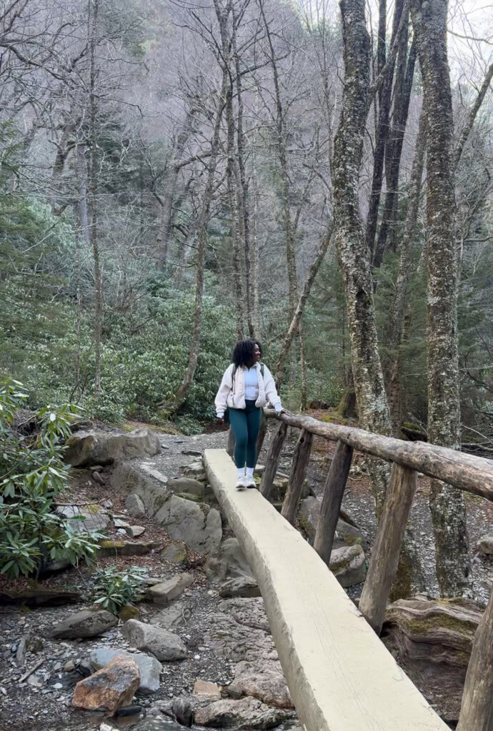
This trail definitely keeps things interesting. It starts off mellow with a peaceful walk through the woods, but after the first mile, the terrain shifts and the adventure begins. One of the first big features is Arch Rock, where you’ll climb a narrow stone staircase through a tunnel carved into the rock, mossy, shaded, and unlike anything else on the trail.
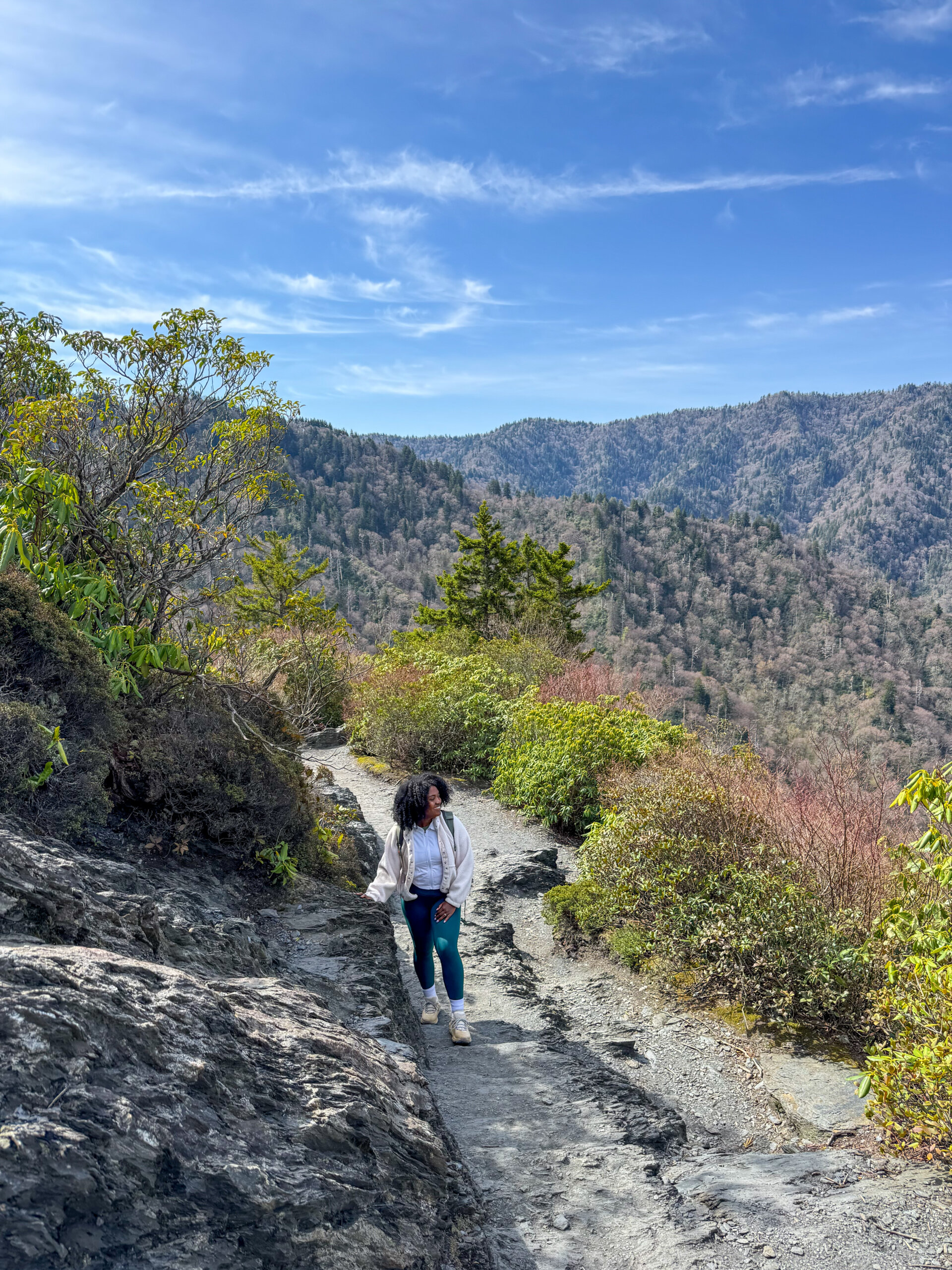
A little further up, you’ll reach Inspiration Point, a rocky outcrop that opens up to wide views of the valley below and the surrounding peaks. And then of course, there’s Alum Cave Bluffs, a towering 80-foot rock overhang that looks and feels like a natural amphitheater. In winter, water drips down and freezes into long icicles, giving it an entirely different vibe.
The trail is well-maintained, but it can definitely be slick if it’s wet or icy. There are wooden bridges, log steps, and built-in trail features to help with footing, but trekking poles are a good idea, especially for the descent. One thing to keep in mind: dogs aren’t allowed on this trail, so if you’re hiking with pets, you’ll want to choose a different route.
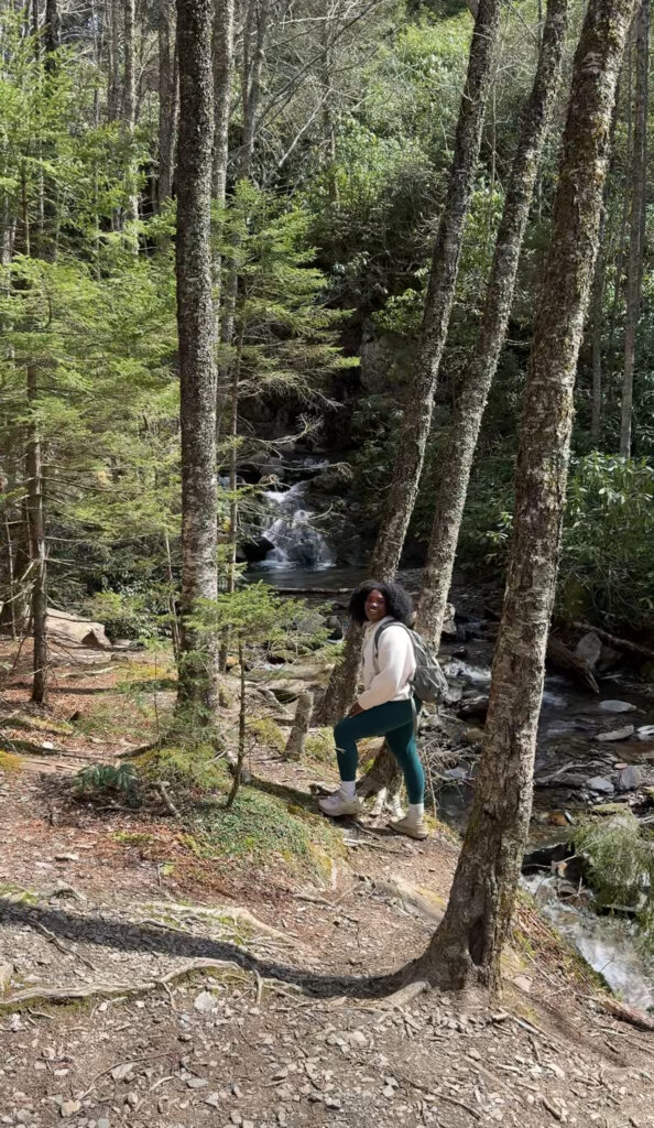
Along the way, you’ll also pass Alum Cave Creek, which flows alongside the lower part of the trail and adds that perfect background sound. Between the rushing water, the forest views, and the dramatic rock formations, there’s no shortage of things to stop and take in.
And if you’re heading all the way to Mount Le Conte, you’ll pass through even more beautiful sections before reaching one of the tallest peaks in the Smokies, and the chance to stay overnight at the iconic LeConte Lodge (if you book early enough).
Maps & Trail Resources:
Here are some helpful links before you hit the Alum Cave Trailhead:
- 🗺️ AllTrails – Alum Cave Trail to Mount Le Conte
- 📄 Printable Map via Hiking in the Smokys
- 🏞️ Official NPS Trail Info
Download maps or save them offline—cell service drops off quickly once you hit the trail.
What to Pack for Alum Cave Trailhead:
Even though it’s only about 4.4 miles round trip to Alum Cave Bluffs, being prepared makes a big difference, especially if the weather shifts or your hike takes longer than expected. Bring at least 1–2 liters of water to stay hydrated, and pack a few snacks like energy bars, fruit, or sandwiches if you plan to relax and refuel at the Bluffs.
The weather can change quickly as you gain elevation, so it’s smart to bring layers, what feels warm at the trailhead can be chilly up top. If you’re hiking in the warmer months, a rain jacket is a good idea since afternoon showers are pretty common.
Trekking poles can be a game changer on the way down, your knees will thank you later. And while this trail doesn’t usually take all day, tossing a headlamp or flashlight in your pack is just smart in case you’re hiking later (or earlier) than planned.
Finally, don’t forget your camera or phone, the views along this trail are some of the best in the Smokies, and you’ll want to capture them.