

Post Summary – the best Great Smoky Mountains waterfalls
The Great Smoky Mountains waterfalls are full of adventure, from easy roadside stops to rewarding hikes with big views. This list of the top Great Smoky Mountains waterfalls gives you everything you need to plan your day, including trail distance, difficulty, parking info, and important updates before you go.
Map of the Great Smoky Mountains Waterfalls
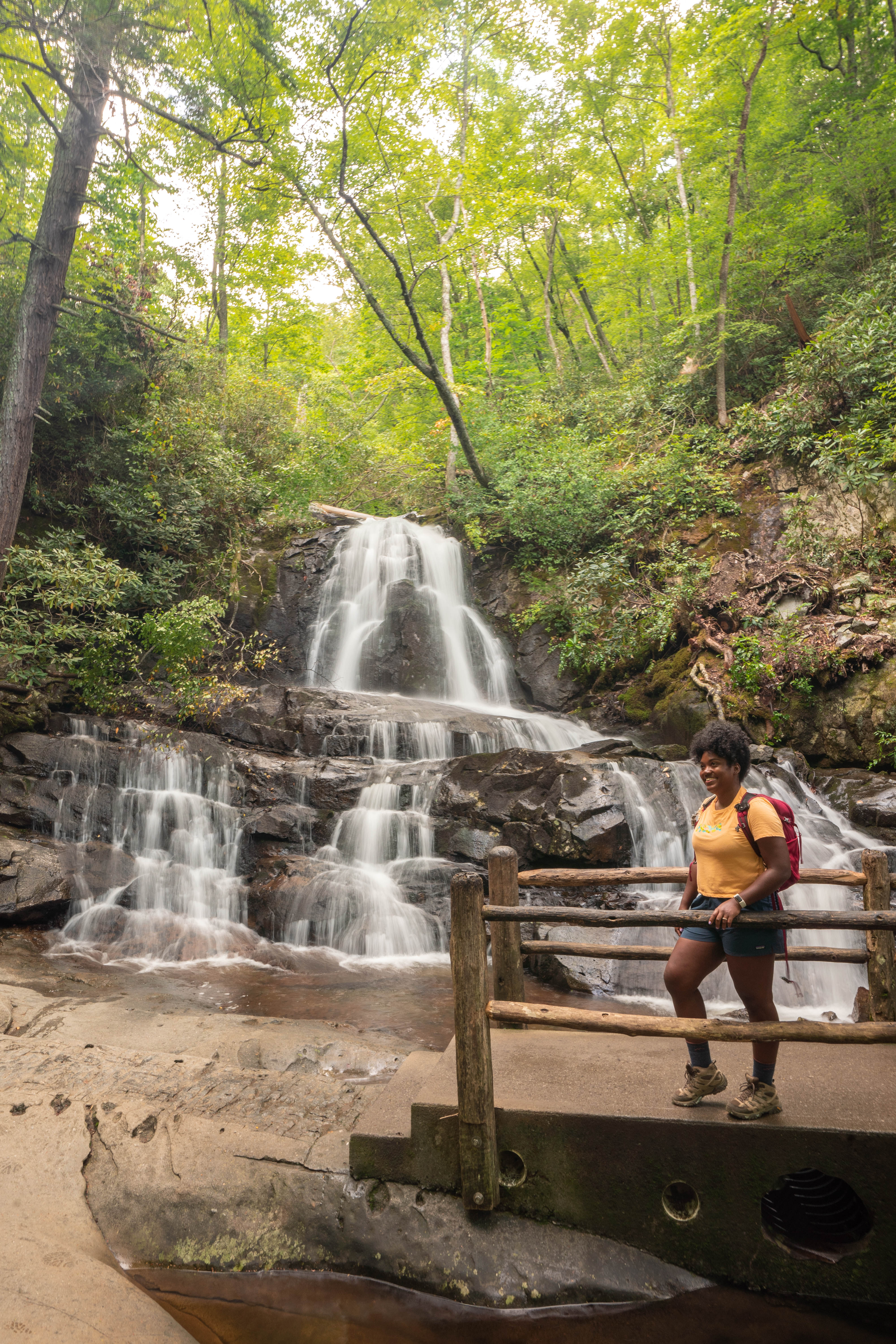
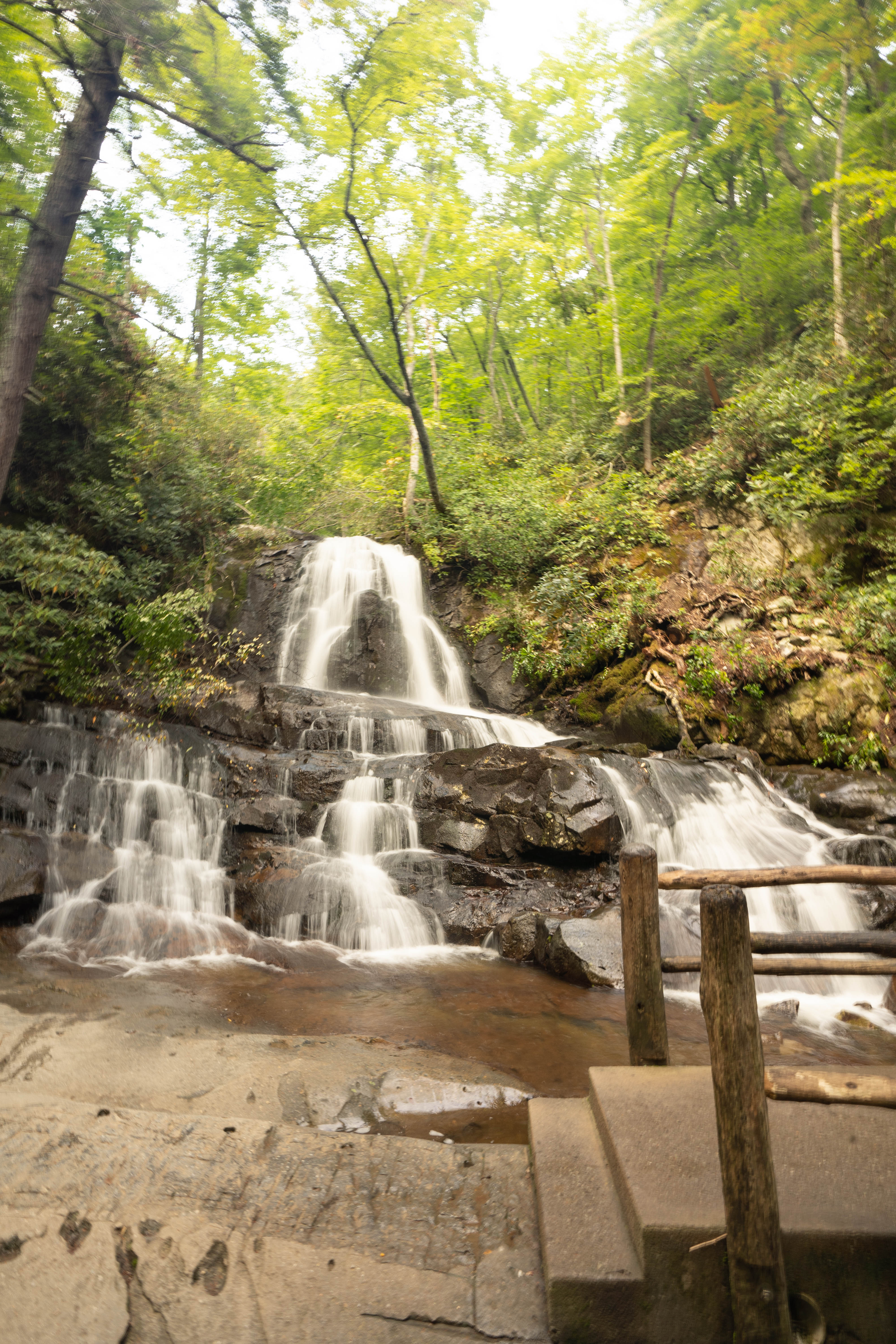
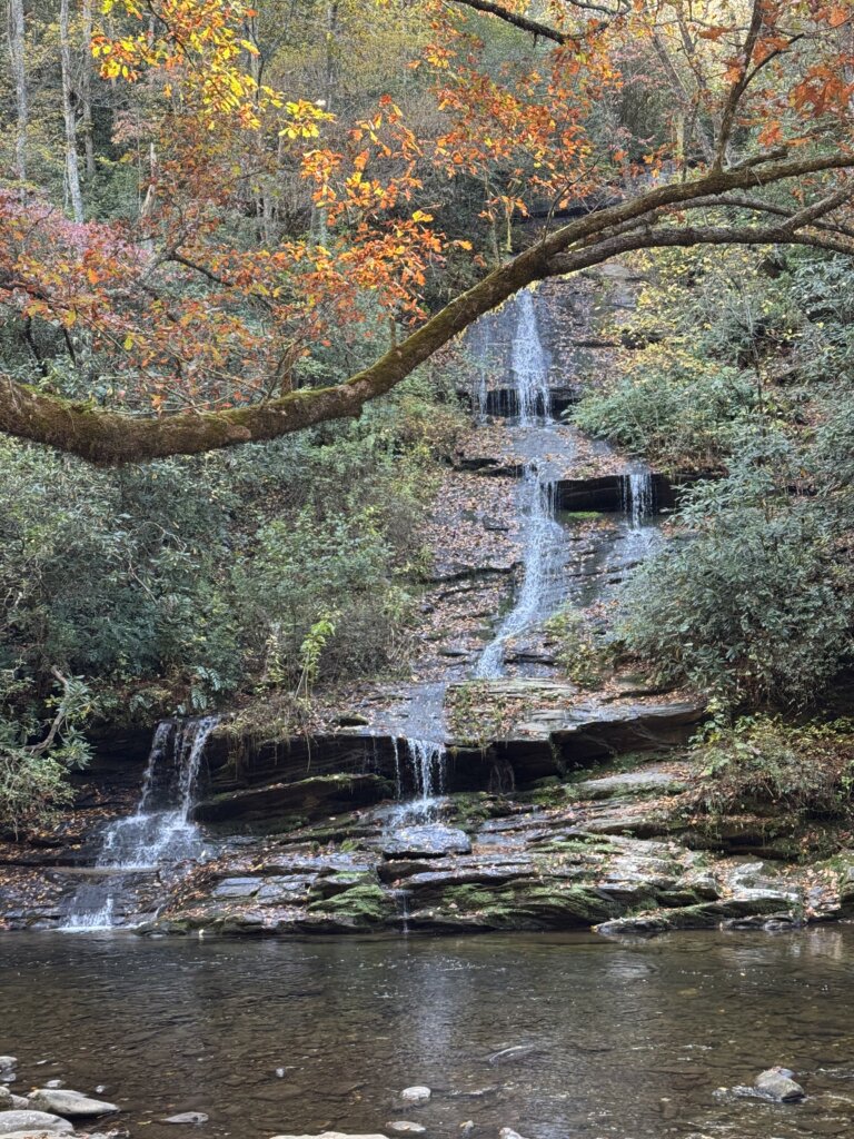
1. Laurel Falls
- Trail Name: Laurel Falls Trail (AllTrails)
- Location: 3.8 miles west of Sugarlands Visitor Center on Little River Road, TN, 35.6714801, -83.5907221
- Distance: 2.6 miles round trip
- Difficulty: Easy to Moderate
- Estimated Time: 1 to 1.5 hours
- Parking: Small lot at trailhead, fills quickly on weekends
- Trail Conditions: Mostly paved, uneven and narrow in spots; not stroller-friendly
- Trail Status: 🚧 Currently closed for restoration (Summer 2025). Check NPS updates.
Laurel Falls is one of the most popular Great Smoky Mountains waterfalls. The trail is only 2.6 miles round-trip, and it starts just off Little River Road, about four miles from Sugarlands Visitor Center. The path is paved but still uneven in spots, so you’ll want good shoes and a little patience as you move around the narrow sections. It’s not stroller-friendly, and parking fills up early on weekends, so timing helps a lot.
The star of the trail is the 80-foot waterfall that splits into an upper and lower section. A small walkway crosses the stream and puts you right between the two drops, which makes it easy to get photos without needing to scramble over rocks. In late spring, mountain laurel blooms along the trail and adds a little extra beauty to the walk.
As of Summer 2025, the trail is temporarily closed for restoration, so it’s important to check NPS updates before planning your day. The closure is a good reminder of how much love this trail gets each year and why maintenance is needed to keep it safe. Once it reopens, Laurel Falls will continue to be a go-to stop for visitors. It’s simple, beautiful, and easy to fit into almost any Great Smoky Mountains waterfalls adventure.
See Also: 13 Amazing Hikes in the Great Smoky Mountains
2. Grotto Falls
- Trail Name: Trillium Gap Trail (AllTrails)
- Location: Roaring Fork Motor Nature Trail, Gatlinburg, TN
- Distance: 2.6 miles round trip
- Difficulty: Moderate
- Estimated Time: About 1.5 hours
- Parking: Limited roadside parking; check park shuttle info
Grotto Falls is an absolute must when it comes to Great Smoky Mountains waterfalls. It begins along the Roaring Fork Motor Nature Trail and takes you on a 2.6-mile round-trip walk through old-growth hemlock forest. Parking is limited along the roadside, so the shuttle is worth checking out if you’re visiting during busier months.
The trail stays cool and shaded, which makes it a great pick for warmer days. The final stretch brings you to the 25-foot waterfall, and the highlight is that you can actually walk behind it. The spray feels refreshing, and you can grab easy photos without climbing over slick rocks.
Because the rocks near the falls stay damp, it can get slippery, so move slowly as you walk around the back side of the waterfall. The shaded rock walls are a good place to spot salamanders. Trillium Gap Trail offers an up-close waterfall experience that gives you a completely different view of the Smokies.
3. Abrams Falls
- Trail Name: Abrams Falls Trail (AllTrails)
- Location: Cades Cove Loop Road, TN
- Distance: 5 miles round trip
- Difficulty: Moderate
- Estimated Time: 2 to 3 hours
- Parking: Trailhead lot on Cades Cove Loop Road
Abrams Falls is one of the most well-known hikes in Cades Cove and the Great Smoky Mountains waterfalls. Parking is right off Cades Cove Loop Road, but it fills up early on busy days, so arriving ahead of the crowd helps. The trail gives you steady views the entire way. It’s a 5-mile round-trip walk that follows the Abrams Creek. The trail stays moderate with a few rocky sections and short climbs that keep things interesting without feeling overwhelming.
The waterfall may only be 20 feet tall, but the power of the water is what makes it stand out. It’s a popular spot for photographers who want long-exposure shots and for fly-fishers who love the creek along the way. The area around the falls stays damp, so watch your footing as you explore the overlook.
Swimming is strongly discouraged due to strong currents and hidden drop-offs, but you won’t feel like you’re missing anything. The view alone is impressive, and the setting feels calm once you settle in and take it all in. Abrams Falls is a great choice and easily one of the most beautiful Great Smoky Mountains waterfalls.
4. Rainbow Falls
- Trail Name: Rainbow Falls Trail (AllTrails)
- Location: Cherokee Orchard Road near Gatlinburg, TN, 35°40’33.0″N 83°29’07.0″W
- Distance: 5.1 miles round trip
- Difficulty: Moderate to Strenuous
- Estimated Time: 3 to 4 hours
- Parking: Small lot, plus limited roadside parking
Rainbow Falls Trail is one of the more challenging waterfall hikes near Gatlinburg. The 5.1-mile round-trip route climbs more than 1,500 feet, so expect a steady workout from the beginning. The trail mixes rocks, roots, and narrow sections, and the elevation gain is noticeable early on.
The waterfall itself is the tallest single-drop fall in the Smokies at about 80 feet. On sunny afternoons, a rainbow can appear in the mist, which is how it got its name.
Winter brings an extra layer of beauty when icicles form along the cliff. The rocks stay slick year-round near the base, so move carefully as you explore the viewpoint. Rainbow Falls Trail is tough but rewarding, and the payoff at the end makes the climb worth it, especially for Great Smoky Mountains waterfalls.
5. The Sinks
- Trail Name: Meigs Creek Trail (AllTrails)
- Location: Little River Road between Metcalf Bottoms and Elkmont, TN
- Distance: About 0.1 miles from parking lot to falls overlook
- Difficulty: Very Easy
- Estimated Time: 15 to 30 minutes
- Parking: Small roadside lot at waterfall
The Sinks is one of the easiest Great Smoky Mountains waterfalls, and you barely have to leave the parking lot to see it. The overlook sits just a short walk from the small roadside pull-off, making it a quick stop on any Scenic Little River Road drive.
The cascade was formed by a sharp bend in the Little River, and the force of the water is the first thing you notice. On certain days, you might even see kayakers navigating the rapids downstream, which adds a fun element to the view.
Even though the pool looks inviting, swimming here is extremely dangerous because of strong currents and hidden drop-offs. The overlook gives you all the views you need without getting close to the water. If you’re exploring the Smokies and want a quick, impressive stop that doesn’t require a full hike, The Sinks is an easy choice.
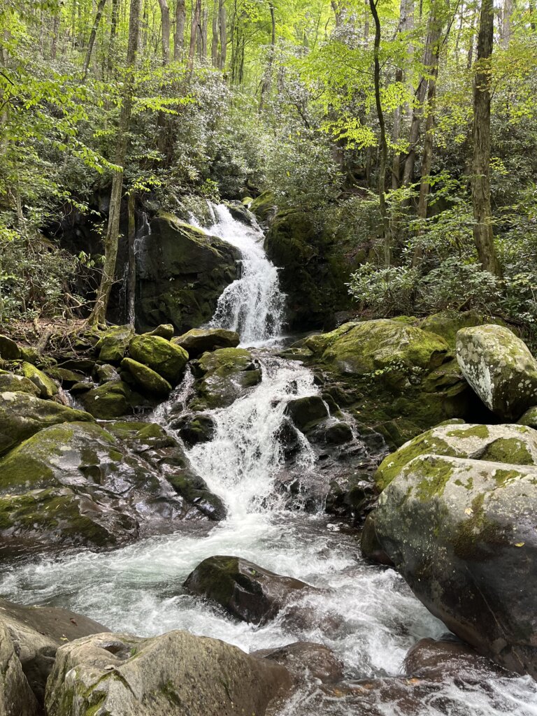
6. Deep Creek Trail System – Indian Creek, Tom Branch & Juney Whank Falls
- Trail Name: Deep Creek Trail System (AllTrails)
- Location: Deep Creek, Bryson City, NC
- Distance: 2.4 miles loop
- Difficulty: Easy to Moderate
- Estimated Time: 1.5 to 2 hours
- Parking: Deep Creek Trailhead – Coordinates: 35.4483, -83.4442
The Deep Creek Trail system is one of the easiest ways to see multiple waterfalls in a single hike near Bryson City. The 2.4-mile loop starts from the Deep Creek Trailhead and stays manageable with a mix of gentle climbs and wide, easy-to-follow paths. It’s popular for families, photographers, and anyone wanting a calm walk without a long day in the woods.
The first waterfall, Juney Whank Falls, sits just a short but steep walk from the parking area. A wooden footbridge puts you right beside the 40-foot cascade, and there’s a small bench built into the overlook where you can sit and watch the water. Once you get back to the main trail, Tom Branch Falls comes into view about half a mile in. It drops straight into Deep Creek and has several benches facing the water, which makes it an easy place to pause and take a break.
Indian Creek Falls is the final stop and sits about 0.6 miles beyond Tom Branch. The 25-foot waterfall fans over smooth rock and feels more secluded than the first two. With three waterfalls, easy access, and plenty of scenery along the way, the Deep Creek loop is one of the most enjoyable Great Smoky Mountains waterfalls.
7. Baskins Creek Falls
- Trail Name: Baskins Creek Trail (AllTrails)
- Location: Roaring Fork Motor Nature Trail, TN, 35.67747, -83.48177
- Distance: 3.7 miles round trip
- Difficulty: Moderate
- Estimated Time: 2 to 3 hours
- Parking: Limited roadside pull-offs
Baskins Creek Trail is a quieter option off the Roaring Fork Motor Nature Trail, and it’s one of the more underrated sections of the Smokies. The 3.7-mile round-trip route starts with an easy downhill stretch that feels relaxing at first, but keep in mind you’ll be climbing back out on the return.
The waterfall itself is a beautiful two-tier, 40-foot drop that feels far removed from the busier trails in the area. It’s a great choice if you want a waterfall experience without weaving through groups of people. The climb out is a workout, but the quiet atmosphere and the payoff at the falls make it worth it.
8. Mouse Creek Falls
- Trail Name: Mouse Creek Falls via Big Creek Trail (AllTrails)
- Location: Near Big Creek Campground, NC
- Distance: 4 miles round trip
- Difficulty: Easy to Moderate
- Estimated Time: 2 to 3 hours
- Parking: Ample near campground
- Trail Conditions: Wide gravel path, follows a creek
Mouse Creek Falls is one of the most relaxing Great Smoky Mountains waterfalls on the North Carolina side of the Smokies. The 4-mile round-trip trail starts near Big Creek Campground and follows a wide gravel path the entire way. Since it was once a logging road, the grade stays gentle, which makes the hike feel approachable for most visitors. You’ll walk beside Big Creek for much of the route, with steady views of rushing water and plenty of spots to pause without blocking the trail.
The waterfall sits about two miles in and drops roughly 45 feet into a calm, clear pool. The overlook gives you a clear view without needing to scramble over rocks, and there’s plenty of space to sit, rest, or just listen to the creek for a moment before heading back.
The trail is known for being family-friendly and pet-friendly, which adds to its appeal during warmer months. As of Summer 2025, the route is closed, so it’s worth saving for a future trip once conditions improve. When it reopens, Mouse Creek Falls will be an easy pick for anyone wanting a smooth trail, steady creek views, and a waterfall that feels quiet and inviting.
9. Spruce Flats Falls
- Trail Name: Spruce Flats Falls via Lumber Ridge Trail (AllTrails)
- Location: Behind Tremont Institute, 35°38’29.2″N 83°41’22.4″W
- Distance: 2 miles round trip
- Difficulty: Easy to Moderate
- Estimated Time: 1.5 to 2 hours
- Parking: Small lot at Tremont Institute
Spruce Flats Falls is one of the best, “unofficial” hikes in the Smokies, found just behind the Tremont Institute. The route is about 2 miles round trip and mixes gentle stretches with a few steep, rocky spots that keep things interesting. Parking is limited to a small lot at Tremont, so arriving early helps, especially on weekends.
The waterfall drops over a series of rock ledges, creating a layered effect that looks different from every angle. The spray feels cool on warmer days, and there’s enough space to sit and enjoy the view without crowding other hikers.
Because it isn’t listed on most official park maps, Spruce Flats Falls feels more off-the-beaten-path than it actually is. The short distance and manageable terrain make it a good pick for anyone wanting a quick adventure with a big reward. If you’re hoping to avoid the busier trails while still getting a standout waterfall, this Great Smoky Mountains waterfall fits perfectly.
10. Mingo Falls
- Trail Name: Mingo Falls Trail (AllTrails)
- Location: Near Cherokee, NC (outside GSMNP), 35°32’03.3″N 83°16’34.5″W
- Distance: 0.3 miles round trip
- Difficulty: Moderate (lots of stairs)
- Estimated Time: 30 to 45 minutes
- Parking: Small lot near trailhead
- Status: Closed June 5–August 2025. See EBCI Update
Mingo Falls is one of the most impressive Great Smoky Mountains waterfalls near Cherokee, standing at more than 120 feet. The trail is only 0.3 miles round trip, but the climb is no joke. A long staircase leads you up through the trees, and the steady elevation hits quickly.
At the top of the stairs, a wooden bridge gives you a full view of the waterfall. The height alone makes it worth the effort, and the flow feels powerful, especially after a good rain. The drop is tall, straight, and dramatic, and the bridge puts you close enough to feel the cool air without navigating slick rocks.
Even though the trail is short, the climb can feel strenuous, so it helps to pace yourself and bring water. The route was closed from June 5 to August 2025, so check for updates before planning your stop.